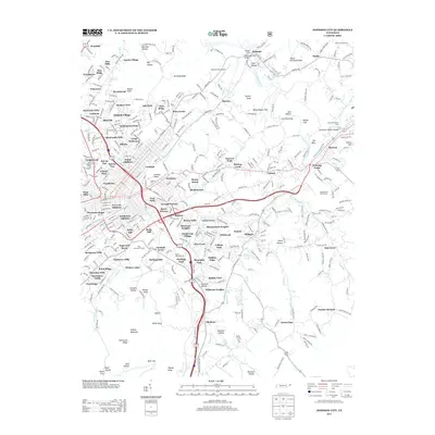
2013 Map of Johnson City
USGS Topo · Published 2013About this map
The Watauga River meanders across the northeast corner of this 2013 survey, framing Lacy Islands and flowing past Sycamore Shoals Island near the city's outskirts. This modern topography illustrates the dense residential expansion of Johnson City, highlighting several established neighborhoods and additions such as Austin Village, Piney Grove, and the N C Love Addition. To the south, the terrain rises sharply into the high ridges of Buffalo Mountain and Whiterock Ridge, while the localized heights of the Tannery Knobs overlook the urban center.
Find a feature on this map
116 named features on this map. Tap any name to fly to it.
Don’t see what you’re looking for? This feature index may not catch every label — zoom into the map to look around manually.
Map Details
Editions of this 2013 Johnson City Map
This is the sole edition of this map. No revisions or reprints were ever made.
Other maps of this area

1891 · Roan Mountain
USGS Topo · 1:125,000

1894 · Roan Mountain
USGS Topo · 1:125,000

1904 · Roan Mountain
USGS Topo · 1:125,000

1934 · Iron Mtn Gap
USGS Topo · 1:24,000

1935 · Watauga Valley
USGS Topo · 1:48,000

1935 · Erwin
USGS Topo · 1:24,000

1935 · Spurgeon
USGS Topo · 1:24,000

1935 · Elizabethton
USGS Topo · 1:24,000
1935 · Unicoi
USGS Topo · 1:24,000
1935 · Bluff City
USGS Topo · 1:24,000