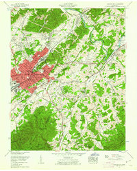
1955 Map of Johnson City
USGS Topo · Published 1955About this map
Buffalo Mountain rises sharply over the urban expansion of Johnson City, providing a topographical anchor for this mid-century portrait of Washington and Carter Counties. The city's downtown core, densifying along the Southern Railway and Clinchfield Railroad, is framed by educational and federal institutions including East Tennessee State College and the sprawling Veterans Administration Center at Mountain Home. Industrial landmarks like the Watauga Steam Plant on the Watauga River and the Sewage disposal plant contrast with the historic landscape of Sycamore Shoals. Moving toward Elizabethton, the map reveals a network of rural life defined by family-named cemeteries such as St John Cem and small rural churches like Patton Chapel. The transition from the high-density residential streets of Keystone and Roan Hill to the forested slopes of the Cherokee National Forest illustrates the region's rapid postwar growth into the surrounding mountain foothills.
Find a feature on this map
143 named features on this map. Tap any name to fly to it.
Don’t see what you’re looking for? This feature index may not catch every label — zoom into the map to look around manually.
Map Details
Editions of this 1955 Johnson City Map
This is the sole edition of this map. No revisions or reprints were ever made.
Other maps of this area

1891 · Roan Mountain
USGS Topo · 1:125,000

1894 · Roan Mountain
USGS Topo · 1:125,000

1904 · Roan Mountain
USGS Topo · 1:125,000

1934 · Iron Mtn Gap
USGS Topo · 1:24,000

1935 · Watauga Valley
USGS Topo · 1:48,000

1935 · Erwin
USGS Topo · 1:24,000

1935 · Spurgeon
USGS Topo · 1:24,000

1935 · Elizabethton
USGS Topo · 1:24,000
1935 · Unicoi
USGS Topo · 1:24,000
1935 · Bluff City
USGS Topo · 1:24,000