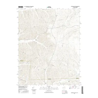
2016 Map of Johnson Hollow
USGS Topo · Published 2016About this map
The Kentucky Tennessee border defines the lower section of this topographic landscape, where the wooded drainages of Trigg and Stewart counties converge. Family history is well-represented across the terrain by several small burial grounds, including Moore Cem, Lancaster Cem, and Hunter Cem, which serve as markers of the area's rural heritage. The namesake Johnson Hollow is joined by other local settlements like Summer Hollow and Cheatam Hollow, tucked into the valleys of a highly dissected plateau. A complex network of local routes, such as Old Dover Rd and Skinner Creek Rd, follows the winding paths of seasonal waterways like Skinner Cr and Dry Cr. This road pattern reveals a community structure dictated by the ridge-and-valley topography, where movement remains concentrated along the natural breaks of the land.
Find a feature on this map
55 named features on this map. Tap any name to fly to it.
Don’t see what you’re looking for? This feature index may not catch every label — zoom into the map to look around manually.
Map Details
Editions of this 2016 Johnson Hollow Map
This is the sole edition of this map. No revisions or reprints were ever made.
Other maps of this area

1936 · Tharpe
USGS Topo · 1:24,000

1950 · Caledonia
USGS Topo · 1:24,000

1951 · Caledonia
USGS Topo · 1:24,000

1951 · Model
USGS Topo · 1:24,000

1951 · Roaring Spring
USGS Topo · 1:24,000

1951 · Johnson Hollow
USGS Topo · 1:24,000
1951 · Tharpe
USGS Topo · 1:24,000

1951 · Indian Mound
USGS Topo · 1:24,000

1951 · Bumpus Mills
USGS Topo · 1:24,000

1953 · Canton
USGS Topo · 1:24,000