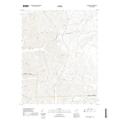
2019 Map of Johnson Hollow
USGS Topo · Published 2019About this map
Johnson Hollow and the surrounding woodlands of Trigg County define this landscape along the Kentucky-Tennessee border. The terrain is characterized by a dense network of ridges and drainages, including Cheatam Hollow and Summer Hollow, which feed into local waterways such as Dry Fork Cr and Saline Cr. This 2019 survey documents a rural environment where land use is tied to the topography, with roads like Old Dover Rd and South Rd following the natural contours of the hills. Family history is preserved through numerous small burial sites scattered across the ridges, including Moore Cem, Atkins Cem, and McKinney Cem. The map provides a detailed view of the infrastructure near the state line, showing the intersection of local routes like Linton Rd and Roaring Springs Rd amidst the deeply dissected plateaus of the region.
Find a feature on this map
63 named features on this map. Tap any name to fly to it.
Don’t see what you’re looking for? This feature index may not catch every label — zoom into the map to look around manually.
Map Details
Editions of this 2019 Johnson Hollow Map
This is the sole edition of this map. No revisions or reprints were ever made.
Other maps of this area

1936 · Tharpe
USGS Topo · 1:24,000

1950 · Caledonia
USGS Topo · 1:24,000

1951 · Caledonia
USGS Topo · 1:24,000

1951 · Model
USGS Topo · 1:24,000

1951 · Roaring Spring
USGS Topo · 1:24,000

1951 · Johnson Hollow
USGS Topo · 1:24,000
1951 · Tharpe
USGS Topo · 1:24,000

1951 · Indian Mound
USGS Topo · 1:24,000

1951 · Bumpus Mills
USGS Topo · 1:24,000

1953 · Canton
USGS Topo · 1:24,000