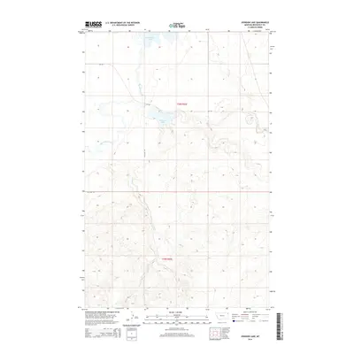
2014 Map of Johnson Lake
USGS Topo · Published 2014About this map
Big Muddy Creek meanders through this portion of Roosevelt County, defining the drainage patterns of a landscape marked by intermittent water and wide plateaus. To the north, Homestead Lake sits near the upper reaches of the creek, while the namesake Johnson Lake occupies a central position within the grid of township and range lines. The terrain is further etched by the paths of Sheep Cr and Sand Cr, which reveal the erosive work of water in this semi-arid environment. Transportation in this section of the Fort Kipp District is anchored by MT-344 and the descriptively named The Slab Rd, providing a framework for understanding the rural connectivity of the region. The map provides a clear look at the Public Land Survey System divisions, including t30n r55e and t29n r55e, which have governed the settlement and agricultural layout of the Montana plains.
Find a feature on this map
9 named features on this map. Tap any name to fly to it.
Don’t see what you’re looking for? This feature index may not catch every label — zoom into the map to look around manually.
Map Details
Editions of this 2014 Johnson Lake Map
This is the sole edition of this map. No revisions or reprints were ever made.
Other maps of this area

1914 · Homestead
USGS Topo · 1:62,500

1947 · Rocky Point
USGS Topo · 1:24,000

1947 · Homestead
USGS Topo · 1:24,000

1948 · Homestead
USGS Topo · 1:24,000

1948 · Rocky Point
USGS Topo · 1:24,000

1948 · Medicine Lake
USGS Topo · 1:24,000

1948 · Fort Kipp
USGS Topo · 1:24,000

1949 · Fort Kipp
USGS Topo · 1:24,000
1949 · Medicine Lake
USGS Topo · 1:24,000

1949 · Johnson Lake
USGS Topo · 1:24,000