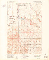
1950 Map of Johnson Lake
USGS Topo · Published 1950About this map
Fort Peck Indian Reservation lands dominate the western portion of this landscape, bounded by the meandering course of Muddy Creek. The terrain is defined by the hydrologic network of the Missouri River Basin, featuring a series of intermittent drainages including Sheep Creek and Sand Creek that cut through the topography. In the north, the Medicine Lake National Wildlife Refuge marks a significant conservation area, while Johnson Lake sits as a central water feature with a nearby Spring. A small Dam and scattered Gravel Pits indicate localized modifications to the natural landscape during the late 1940s mapping period. The map illustrates the sparsely settled nature of this region, focusing on the natural drainages and administrative boundaries that defined land use at the time.
Find a feature on this map
11 named features on this map. Tap any name to fly to it.
Don’t see what you’re looking for? This feature index may not catch every label — zoom into the map to look around manually.
Map Details
Editions of this 1950 Johnson Lake Map
This is the sole edition of this map. No revisions or reprints were ever made.
Other maps of this area

1914 · Homestead
USGS Topo · 1:62,500

1947 · Rocky Point
USGS Topo · 1:24,000

1947 · Homestead
USGS Topo · 1:24,000

1948 · Homestead
USGS Topo · 1:24,000

1948 · Rocky Point
USGS Topo · 1:24,000

1948 · Medicine Lake
USGS Topo · 1:24,000

1948 · Fort Kipp
USGS Topo · 1:24,000

1949 · Fort Kipp
USGS Topo · 1:24,000
1949 · Medicine Lake
USGS Topo · 1:24,000

1949 · Johnson Lake
USGS Topo · 1:24,000