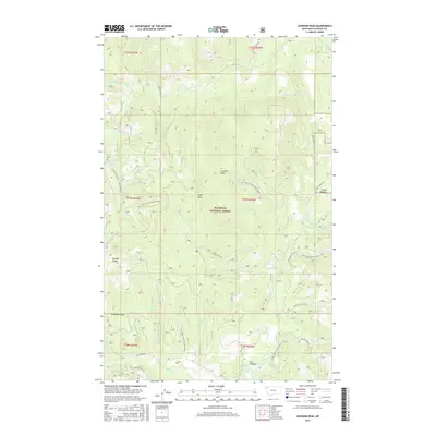
2017 Map of Johnson Peak
USGS Topo · Published 2017About this map
Johnson Peak stands as a central topographic anchor within the Flathead National Forest, part of the larger Salish Mountains system in Montana. This 2017 survey reveals a landscape defined by an intricate network of forest development roads, including Natl Forest Develop Road 2903 Rd and Star Meadow Rd, which provide access to high-elevation features like Trixie Pass and Swaney Ridge. The drainage patterns here are complex, with headwaters for numerous creeks such as Good Cr, Smoke Cr, and Sanko Cr carving through the timbered terrain. The presence of named openings like Star Meadow and Shorts Meadow amidst the dense forest suggests historical areas of grazing or early settlement activity within the mountain range. This map documents the modern management of this public land, showing the detailed logging and access routes that have shaped the forest's utility into the 21st century.
Find a feature on this map
43 named features on this map. Tap any name to fly to it.
Don’t see what you’re looking for? This feature index may not catch every label — zoom into the map to look around manually.
Map Details
Editions of this 2017 Johnson Peak Map
This is the sole edition of this map. No revisions or reprints were ever made.
Other maps of this area

1913 · Stryker
USGS Topo · 1:125,000

1916 · Stryker
USGS Topo · 1:125,000

1957 · Kalispell
USGS Topo · 1:250,000

1960 · Kalispell
USGS Topo · 1:250,000

1961 · Kalispell
USGS Topo · 1:250,000

1962 · Johnson Peak
USGS Topo · 1:24,000

1962 · Lost Creek Divide
USGS Topo · 1:24,000

1962 · Ashley Mountain
USGS Topo · 1:24,000
1962 · Tally Lake
USGS Topo · 1:24,000

1963 · Sylvia Lake
USGS Topo · 1:24,000