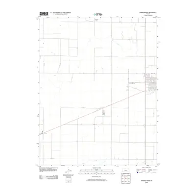
2010 Map of Johnson West
USGS Topo · Published 2010About this map
The High Plains landscape of Stanton County unfolds across this survey, centered on the western approach to Johnson. This agricultural region is defined by a strict section-line road grid, including W Rd 12 and State Hwy 27, which facilitates the movement of crops across the level terrain. Water resources are scarce and vital, marked here by the meandering path of Bear Creek and the southern flow of Sand Arroyo Creek, alongside isolated labels for a Well. Local civic life is anchored at the edge of the settlement near the County Cemetery, while the presence of Cockrum Airport to the north underscores the role of aviation in managing these expansive western Kansas fields. The map reveals the precise organization of rural land use, where local routes like Cemetery Rd and Beatty Ave connect the town center to its surrounding prairie.
Find a feature on this map
28 named features on this map. Tap any name to fly to it.
Don’t see what you’re looking for? This feature index may not catch every label — zoom into the map to look around manually.
Map Details
Editions of this 2010 Johnson West Map
This is the sole edition of this map. No revisions or reprints were ever made.
Other maps of this area

1900 · Syracuse
USGS Topo · 1:125,000

1920 · Syracuse
USGS Topo · 1:125,000

1955 · Dodge City
USGS Topo · 1:250,000

1958 · Dodge City
USGS Topo · 1:250,000

1959 · Dodge City
USGS Topo · 1:250,000

1959 · Big Bow NW
USGS Topo · 1:24,000

1959 · Big Bow SW
USGS Topo · 1:24,000

1973 · Richfield NW
USGS Topo · 1:24,000
1973 · Johnson NW
USGS Topo · 1:24,000

1973 · Shore Airport
USGS Topo · 1:24,000