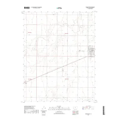
2018 Map of Johnson West
USGS Topo · Published 2018About this map
Johnson City and Manter anchor this corner of the High Plains, where a rigid grid of section roads defines the agricultural landscape of Stanton County. The area is characterized by vast tracts of farmland segmented by routes like W Rd 12 and N Rd R. In the eastern portion of the map, the Stanton County Cem sits just outside the organized street plan of Johnson City, where residential thoroughfares such as W Ellsworth Ave and W Highland Ave concentrate the local population. To the south, the ephemeral drainage of Sand Arroyo Cr cuts a meandering path across the township lines, offering a rare break in the geometric precision of the territory. This 2018 survey provides an exact record of contemporary land use, showing the transition from the concentrated urban blocks of the county seat to the expansive rural sections that dominate the western Kansas terrain.
Find a feature on this map
49 named features on this map. Tap any name to fly to it.
Don’t see what you’re looking for? This feature index may not catch every label — zoom into the map to look around manually.
Map Details
Editions of this 2018 Johnson West Map
This is the sole edition of this map. No revisions or reprints were ever made.
Other maps of this area

1900 · Syracuse
USGS Topo · 1:125,000

1920 · Syracuse
USGS Topo · 1:125,000

1955 · Dodge City
USGS Topo · 1:250,000

1958 · Dodge City
USGS Topo · 1:250,000

1959 · Dodge City
USGS Topo · 1:250,000

1959 · Big Bow NW
USGS Topo · 1:24,000

1959 · Big Bow SW
USGS Topo · 1:24,000

1973 · Richfield NW
USGS Topo · 1:24,000
1973 · Johnson NW
USGS Topo · 1:24,000

1973 · Shore Airport
USGS Topo · 1:24,000