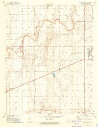
1973 Map of Johnson West
USGS Topo · Published 1975About this map
Johnson (Johnson City) serves as the primary hub of this High Plains landscape, situated at the eastern edge of the survey where the prairie meets an extensive network of water management and irrigation wells. The Atchison Topeka and Santa Fe railroad bisects the southern half of the quadrangle, reflecting the critical role of rail transport in the regional agricultural economy during the early 1970s. The terrain is defined by the winding paths of Bear Creek and Sand Arroyo Creek, which carve distinct drainage patterns across the county. Local infrastructure is noted by features like the Cockrum Airport, a Fish Farm, and the County Cemetery, while the small settlement of Baughman appears further south. The prevalence of individual wells across the map underscores the area's reliance on groundwater for both domestic use and farming operations in Stanton County.
Find a feature on this map
15 named features on this map. Tap any name to fly to it.
Don’t see what you’re looking for? This feature index may not catch every label — zoom into the map to look around manually.
Map Details
Editions of this 1973 Johnson West Map
This is the sole edition of this map. No revisions or reprints were ever made.
Other maps of this area

1900 · Syracuse
USGS Topo · 1:125,000

1920 · Syracuse
USGS Topo · 1:125,000

1955 · Dodge City
USGS Topo · 1:250,000

1958 · Dodge City
USGS Topo · 1:250,000

1959 · Dodge City
USGS Topo · 1:250,000

1959 · Big Bow NW
USGS Topo · 1:24,000

1959 · Big Bow SW
USGS Topo · 1:24,000

1973 · Richfield NW
USGS Topo · 1:24,000
1973 · Johnson NW
USGS Topo · 1:24,000

1973 · Shore Airport
USGS Topo · 1:24,000