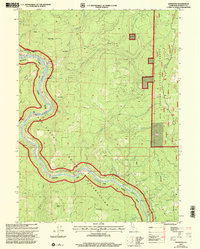
1997 Map of Johnsons
USGS Topo · Published 2001About this map
The Klamath River carves a deep, winding path through Northern California, serving as the central artery for this portion of the Hoopa Valley Indian Reservation. In the late 1990s, small settlements like Johnsons and Pecwan remained anchored to the riverbanks, connected by the narrow corridor of Johnson Road. The geography here is defined by steep drainage basins where Pecwan Creek and Acheith Creek flow down from the high ridgelines of the Six Rivers National Forest. Local life is marked by community landmarks such as the Jack Norton School near Surgone and several small Cem sites. The landscape shifts from the river flats at Cappell Flat to the open high ground of Racehorse Prairie, illustrating the dramatic verticality of the Klamath Mountains.
Find a feature on this map
42 named features on this map. Tap any name to fly to it.
Don’t see what you’re looking for? This feature index may not catch every label — zoom into the map to look around manually.
Map Details
Editions of this 1997 Johnsons Map
This is the sole edition of this map. No revisions or reprints were ever made.
Other maps of this area

1925 · Hoopa
USGS Topo · 1:125,000

1945 · Coyote Peak
USGS Topo · 1:62,500

1945 · Tectah Creek
USGS Topo · 1:62,500

1948 · Weed
USGS Topo · 1:250,000

1950 · Weed
USGS Topo · 1:250,000

1952 · Coyote Peak
USGS Topo · 1:62,500

1952 · Hoopa
USGS Topo · 1:62,500

1952 · Orleans
USGS Topo · 1:62,500

1952 · Tectah Creek
USGS Topo · 1:62,500

1958 · Weed
USGS Topo · 1:250,000