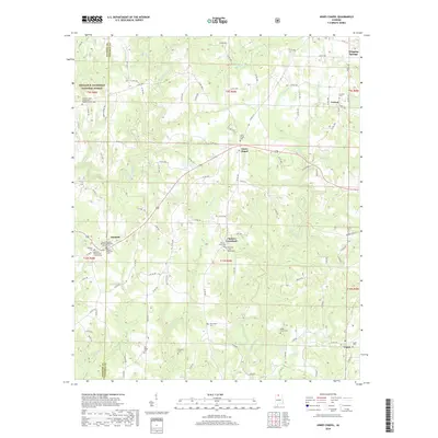
2018 Map of Jones Chapel
USGS Topo · Published 2018About this map
Jones Chapel and the surrounding rural communities of Cullman and Winston Counties are captured in this modern survey. The landscape is defined by the winding paths of Sullivan Cr, Crooked Creek, and Whetstone Cr, which carve through the plateau terrain. A significant portion of the western sheet is occupied by the William B. Bankhead National Forest, reflecting the region's commitment to timber and wilderness preservation. Settlement patterns are concentrated around crossroads like Chances Crossroad and Nesmith, where family-named landmarks and country churches serve as local anchors. Genealogists will find an exceptional concentration of burial grounds, ranging from Lebanon Cem and Pine Ridge Cem to the denominational sites of Mount Pleasant Missionary Baptist Church Cem and Nesmith Methodist Church Cem. These small settlements, connected by a network of county roads, preserve the rural character of northern Alabama into the twenty-first century.
Find a feature on this map
119 named features on this map. Tap any name to fly to it.
Don’t see what you’re looking for? This feature index may not catch every label — zoom into the map to look around manually.
Map Details
Editions of this 2018 Jones Chapel Map
This is the sole edition of this map. No revisions or reprints were ever made.
Other maps of this area

1888 · Cullman
USGS Topo · 1:125,000

1892 · Cullman
USGS Topo · 1:125,000

1927 · Falkville
USGS Topo · 1:24,000

1935 · Upshaw
USGS Topo · 1:24,000

1935 · Danville
USGS Topo · 1:48,000

1936 · Mc Kendry
USGS Topo · 1:24,000

1938 · Danville
USGS Topo · 1:62,500

1949 · Falkville
USGS Topo · 1:24,000
1951 · Falkville
USGS Topo · 1:24,000

1956 · Gadsden
USGS Topo · 1:250,000