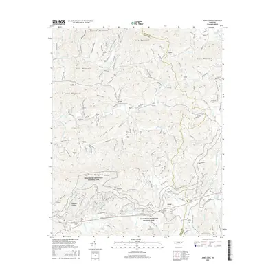
2016 Map of Jones Cove
USGS Topo · Published 2016About this map
Great Smoky Mountains National Park defines the southern portion of this landscape, where the foothills of the Smokies meet the rural communities of eastern Tennessee. The terrain is marked by high ridges like English Mountain and Chestnut Ridge, creating a network of deep hollows and gaps such as Hurst Gap and Blackgum Gap. This environment fostered a dispersed settlement pattern focused on small hamlets like Jones Cove and Pittman Center.
Find a feature on this map
184 named features on this map. Tap any name to fly to it.
Don’t see what you’re looking for? This feature index may not catch every label — zoom into the map to look around manually.
Map Details
Editions of this 2016 Jones Cove Map
This is the sole edition of this map. No revisions or reprints were ever made.
Other maps of this area

1893 · Mt Guyot
USGS Topo · 1:125,000

1912 · Mt Guyot
USGS Topo · 1:125,000

1935 · Newport
USGS Topo · 1:48,000

1935 · Hartford
USGS Topo · 1:24,000

1935 · English Mountain
USGS Topo · 1:48,000

1935 · Clevenger
USGS Topo · 1:24,000

1935 · Jones Cove
USGS Topo · 1:24,000

1935 · Richardson Cove
USGS Topo · 1:24,000
1935 · Shady Grove
USGS Topo · 1:24,000
1936 · Cartertown
USGS Topo · 1:24,000