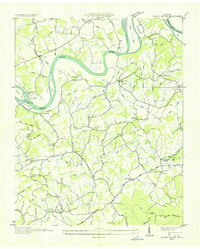
1935 Map of Shady Grove
USGS Topo · Published 1935About this map
Arthur E. Morgan and the Tennessee Valley Authority oversaw this mid-1930s survey, documenting the French Broad River valley along the border of Jefferson and Sevier counties. The landscape is defined by the winding river and its numerous islands, including Ernest Fox Island and Bird Island. Away from the water, a dense network of country schools like Parrott Sch and Alley Sch served rural families during the Depression era.
Find a feature on this map
64 named features on this map. Tap any name to fly to it.
Don’t see what you’re looking for? This feature index may not catch every label — zoom into the map to look around manually.
Map Details
Editions of this 1935 Shady Grove Map
This is the sole edition of this map. No revisions or reprints were ever made.
Other maps of this area

1883 · Morristown
USGS Topo · 1:125,000

1886 · Knoxville
USGS Topo · 1:125,000

1892 · Knoxville
USGS Topo · 1:125,000

1893 · Mt Guyot
USGS Topo · 1:125,000

1893 · Morristown
USGS Topo · 1:125,000

1894 · Knoxville
USGS Topo · 1:125,000

1895 · Morristown
USGS Topo · 1:125,000

1895 · Knoxville
USGS Topo · 1:125,000

1897 · Maynardville
USGS Topo · 1:125,000

1900 · Maynardville
USGS Topo · 1:125,000