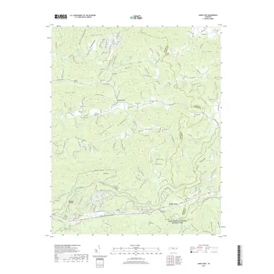
2019 Map of Jones Cove
USGS Topo · Published 2019About this map
Great Smoky Mountains National Park defines the southern portion of this landscape, where the northern boundary of the park meets the settlements of Pittman Center and Jones Cove. This 2019 survey captures a transition between the protected forest and the agricultural and residential highlands of Sevier County and Cocke County. The map is particularly dense with small family burial grounds such as Maddron Cem, Shults- Whaley Cem, and Johnnie Ramsey Cem, reflecting the deep-rooted genealogical history of these mountain communities. Navigable terrain includes paths like the Old Settlers Trail and Maddron Bald Trail, which provide access to features like Snag Mtn and Buckeye Lead. The drainage network, featuring Webb Cr and Dunn Creek, illustrates how these narrow valleys dictated the layout of local roads like Jones Cove Rd and isolated homesteads.
Find a feature on this map
78 named features on this map. Tap any name to fly to it.
Don’t see what you’re looking for? This feature index may not catch every label — zoom into the map to look around manually.
Map Details
Editions of this 2019 Jones Cove Map
This is the sole edition of this map. No revisions or reprints were ever made.
Other maps of this area

1893 · Mt Guyot
USGS Topo · 1:125,000

1912 · Mt Guyot
USGS Topo · 1:125,000

1935 · Newport
USGS Topo · 1:48,000

1935 · Hartford
USGS Topo · 1:24,000

1935 · English Mountain
USGS Topo · 1:48,000

1935 · Clevenger
USGS Topo · 1:24,000

1935 · Jones Cove
USGS Topo · 1:24,000

1935 · Richardson Cove
USGS Topo · 1:24,000
1935 · Shady Grove
USGS Topo · 1:24,000
1936 · Cartertown
USGS Topo · 1:24,000