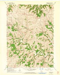
1962 Map of Jonesdale
USGS Topo · Published 1964About this map
The rolling agricultural uplands of Iowa County are deeply dissected by the intricate drainage systems of Dodge Branch, Simmons Branch, and Lynch Branch. In the early 1960s, this landscape is defined by the heavy presence of the Chicago and North Western railroad, which snakes through the northern hills near Dodgeville and the southern valley at Jonesdale. A remnant of earlier transit persists as an Old Grade following the southern watercourses.
Find a feature on this map
20 named features on this map. Tap any name to fly to it.
Don’t see what you’re looking for? This feature index may not catch every label — zoom into the map to look around manually.
Map Details
Editions of this 1962 Jonesdale Map
This is the sole edition of this map. No revisions or reprints were ever made.
Other maps of this area

1902 · Mineral Point
USGS Topo · 1:125,000

1905 · Richland Center
USGS Topo · 1:125,000

1920 · Blue Mounds
USGS Topo · 1:62,500

1922 · Blue Mounds
USGS Topo · 1:62,500

1923 · Blanchardville
USGS Topo · 1:62,500

1952 · Mineral Point
USGS Topo · 1:24,000

1952 · Dodgeville
USGS Topo · 1:24,000

1954 · Rockford
USGS Topo · 1:250,000

1955 · Rockford
USGS Topo · 1:250,000

1957 · Madison
USGS Topo · 1:250,000