1986 Map of Joplin
USGS Topo · Published 1986About this map
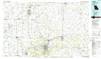
Extensive industrial and transit networks define this borderland region where Missouri, Kansas, and Oklahoma converge. The map documents a landscape heavily shaped by extraction, visible in the numerous Strip Mines and Gravel Pits that dot the terrain, alongside conservation efforts like the Mined Land State Wildlife Area. A dense web of rail lines, including the Atchison Topeka and Santa Fe RR and Kansas City Southern RR, services the hubs of Pittsburg, Kansas, and Joplin, Missouri. The presence of Missouri Southern State College and the Myers Park Memorial Municipal Airport reflects the mid-century institutional growth of the Joplin area. Waterways like the Spring River and Center Creek wind through the region, providing a natural contrast to the grid of U.S. Highways and the newly established I-44 corridor, which together facilitate the heavy commercial traffic characteristic of this tri-state crossroads.
Find a feature on this map
160 named features on this map. Tap any name to fly to it.
Don’t see what you’re looking for? This feature index may not catch every label — zoom into the map to look around manually.
Map Details
Editions of this 1986 Joplin Map
This is the sole edition of this map. No revisions or reprints were ever made.
Other maps of this area

1884 · Fort Scott
USGS Topo · 1:125,000

1886 · Nevada
USGS Topo · 1:125,000

1886 · Joplin
USGS Topo · 1:125,000

1886 · Stockton
USGS Topo · 1:125,000

1886 · Greenfield
USGS Topo · 1:125,000

1886 · Iola
USGS Topo · 1:125,000

1886 · Fort Scott
USGS Topo · 1:125,000

1886 · Carthage
USGS Topo · 1:125,000

1886 · Parsons
USGS Topo · 1:125,000

1888 · Greenfield
USGS Topo · 1:125,000