1991 Map of Joplin
USGS Topo · Published 1991About this map
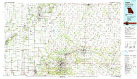
Joplin and Carthage anchor a tri-state border region defined by a dense legacy of lead and zinc mining and a transition from prairie to river valley. The landscape is heavily marked by industrial history, particularly in the Mined Land State Wildlife Area near Pittsburg, where former strip mines have been reclaimed for conservation. The map traces the critical corridor of US Highway 66 through Webb City and Carterville, alongside major rail lines like the Kansas City Southern Railway and the Missouri Pacific Railroad. These transport networks linked the mining district to broader markets, fostering the growth of educational hubs like Missouri Southern State College and Pittsburg State University. Large cemeteries such as Mount Hope Cem and Oak Hill Cem speak to the generations that built these communities around the forks of the Spring River and Center Creek.
Find a feature on this map
161 named features on this map. Tap any name to fly to it.
Don’t see what you’re looking for? This feature index may not catch every label — zoom into the map to look around manually.
Map Details
Editions of this 1991 Joplin Map
This is the sole edition of this map. No revisions or reprints were ever made.
Other maps of this area

1884 · Fort Scott
USGS Topo · 1:125,000

1886 · Nevada
USGS Topo · 1:125,000

1886 · Joplin
USGS Topo · 1:125,000

1886 · Stockton
USGS Topo · 1:125,000

1886 · Greenfield
USGS Topo · 1:125,000

1886 · Iola
USGS Topo · 1:125,000

1886 · Fort Scott
USGS Topo · 1:125,000

1886 · Carthage
USGS Topo · 1:125,000

1886 · Parsons
USGS Topo · 1:125,000

1888 · Greenfield
USGS Topo · 1:125,000