2023 Map of Jordan
USGS Topo · Published 2023About this map
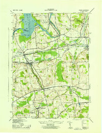
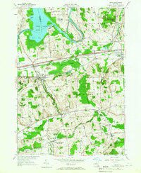
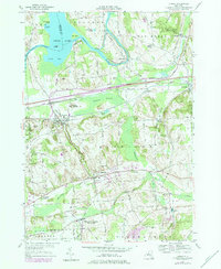
The village of Jordan and the town of Elbridge anchor this Central New York landscape, situated where the historic path of the Old Erie Canal meets the winding waters of Skaneateles Creek. The terrain is defined by a series of prominent drumlins and hills, including Ashbys Pinnacle, Science Hill, and Preston Hill, which rise above the surrounding wetlands of McGraw Swamp and Frog Hole Swamp. To the north, the Seneca River flows through Jacks Reef toward Cross Lake, creating a complex water network that historically supported local industry and transport.
Find a feature on this map
128 named features on this map. Tap any name to fly to it.
Don’t see what you’re looking for? This feature index may not catch every label — zoom into the map to look around manually.
Map Details
Editions of this 2023 Jordan Map
This is the sole edition of this map. No revisions or reprints were ever made.
Historical Maps of Jack's Reef Through Time
4 maps found