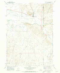
1969 Map of Jordan Valley
USGS Topo · Published 1973About this map
The high desert community of Jordan Valley serves as the focal point of this late-1960s survey, straddling the high plains near the Oregon Idaho border. The map captures the infrastructure of this remote ranching hub, including the Rodeo Grounds, a local Cem, and the High Sch. The landscape is defined by the winding course of Jordan Creek and the surrounding heights of Pharmacy Hill, with water management clearly prioritized through features like the Feeder Canal. To the southeast, the terrain opens into Pleasant Valley Creek, where the Pleasant Valley Sch sits isolated along the creek banks. This document provides a clear record of the intersection between Malheur and Owyhee counties, illustrating how early 20th-century irrigation and school districts organized the arid borderlands.
Find a feature on this map
24 named features on this map. Tap any name to fly to it.
Don’t see what you’re looking for? This feature index may not catch every label — zoom into the map to look around manually.
Map Details
Editions of this 1969 Jordan Valley Map
This is the sole edition of this map. No revisions or reprints were ever made.
Other maps of this area

1892 · Silver City
USGS Topo · 1:125,000

1894 · Silver City
USGS Topo · 1:125,000

1898 · Silver City
USGS Topo · 1:125,000

1955 · Jordan Valley
USGS Topo · 1:250,000

1955 · Boise
USGS Topo · 1:250,000

1957 · Jordan Valley
USGS Topo · 1:250,000

1958 · Boise
USGS Topo · 1:250,000

1958 · Jordan Valley
USGS Topo · 1:250,000

1962 · Boise
USGS Topo · 1:250,000

1965 · Rooster Comb Peak
USGS Topo · 1:62,500