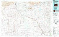
1994 Map of Jordan Valley
USGS Topo · Published 1994About this map
Owyhee Wild and Scenic River carves a deep path through the High Desert of the Oregon-Idaho border, defining the isolation and character of this remote landscape. In the mid-1990s, this area remained largely defined by vast open spaces like the Saddle Butte Lava Field and Antelope Flat. Small ranching hubs and outposts such as Jordan Valley, Rome, and Arock provide the primary human anchors along the winding course of Jordan Creek.
Find a feature on this map
77 named features on this map. Tap any name to fly to it.
Don’t see what you’re looking for? This feature index may not catch every label — zoom into the map to look around manually.
Map Details
Editions of this 1994 Jordan Valley Map
2 editions found
Other maps of this area

1892 · Silver City
USGS Topo · 1:125,000

1894 · Silver City
USGS Topo · 1:125,000

1898 · Silver City
USGS Topo · 1:125,000

1955 · Jordan Valley
USGS Topo · 1:250,000

1955 · Burns
USGS Topo · 1:250,000

1955 · Adel
USGS Topo · 1:250,000

1955 · Boise
USGS Topo · 1:250,000

1957 · Adel
USGS Topo · 1:250,000

1957 · Jordan Valley
USGS Topo · 1:250,000

1958 · Burns
USGS Topo · 1:250,000