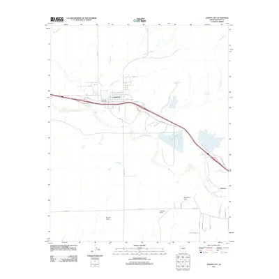
2011 Map of Joseph City
USGS Topo · Published 2011About this map
Joseph City serves as the central hub of this high desert landscape, positioned along the northern bank of the Little Colorado River. The map highlights a complex infrastructure of water and industry, characterized by the Cholla Lake reservoir and specialized industrial features like the Cholla Bottom Ash Pond and Cholla Fly Ash Pond to the east. Transportation history is deeply etched into the terrain, with Old Hwy 66 and Cliff Edge paralleling the modern interstate corridor. To the south and east, the landscape transitions into a series of named drainages, including Randall Draw and Marshall Draw, which cut through the arid plains toward the river. Smaller ranching or water management sites like Hashknife Tank and the settlement of Penzance provide specific points of interest for those studying the rural layout of Navajo County.
Find a feature on this map
37 named features on this map. Tap any name to fly to it.
Don’t see what you’re looking for? This feature index may not catch every label — zoom into the map to look around manually.
Map Details
Editions of this 2011 Joseph City Map
This is the sole edition of this map. No revisions or reprints were ever made.
Other maps of this area

1883 · Tusayan
USGS Topo · 1:250,000

1886 · Tusayan
USGS Topo · 1:250,000

1886 · Holbrook
USGS Topo · 1:250,000

1893 · Holbrook
USGS Topo · 1:250,000

1947 · Flagstaff
USGS Topo · 1:250,000

1954 · Flagstaff
USGS Topo · 1:250,000

1954 · Holbrook
USGS Topo · 1:250,000

1955 · Mal Pais Springs 3 SW
USGS Topo · 1:24,000

1955 · St. Joseph 2 SE
USGS Topo · 1:24,000
1955 · St. Joseph 2 NW
USGS Topo · 1:24,000