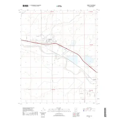
2018 Map of Joseph City
USGS Topo · Published 2018About this map
Joseph City serves as the primary population center on this landscape, structured by a grid of residential streets like Bushman Ave and Randall Ave north of the primary transit corridor. The Little Colorado River winds through the center of the sheet, bordered by the expansive Obed Meadow to the south. This riparian zone is further defined by several seasonal drainage systems, including Manila Wash, Joseph City Wash, and Tanner Wash, which feed toward the river valley. To the east, Cholla Lake provides a significant water feature adjacent to the rail line leading toward Penzance. The map illustrates the close relationship between the high-desert hydrology and the settlement patterns established along the river's path, showing a mix of established town lots and rural road networks like Territorial Rd and McLaws Rd.
Find a feature on this map
40 named features on this map. Tap any name to fly to it.
Don’t see what you’re looking for? This feature index may not catch every label — zoom into the map to look around manually.
Map Details
Editions of this 2018 Joseph City Map
This is the sole edition of this map. No revisions or reprints were ever made.
Other maps of this area

1883 · Tusayan
USGS Topo · 1:250,000

1886 · Tusayan
USGS Topo · 1:250,000

1886 · Holbrook
USGS Topo · 1:250,000

1893 · Holbrook
USGS Topo · 1:250,000

1947 · Flagstaff
USGS Topo · 1:250,000

1954 · Flagstaff
USGS Topo · 1:250,000

1954 · Holbrook
USGS Topo · 1:250,000

1955 · Mal Pais Springs 3 SW
USGS Topo · 1:24,000

1955 · St. Joseph 2 SE
USGS Topo · 1:24,000
1955 · St. Joseph 2 NW
USGS Topo · 1:24,000