1955 Map of Joseph City
USGS Topo · Published 1973About this map
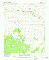
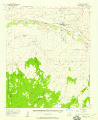
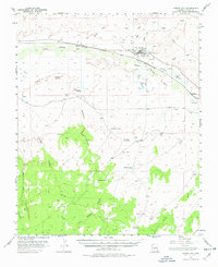
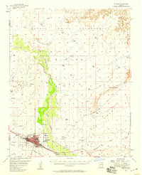
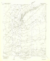
Joseph City serves as the focal point of this Navajo County landscape, situated along the Little Colorado River where Mormon pioneers established roots in the late 19th century. The map captures the infrastructure of the mid-1950s, highlighting the transit corridor formed by U. S. 66 and the Atchison Topeka and Santa Fe railroad. Notable landmarks include The Old Fort Historical Monument, preserving the site of early settlement efforts. To the west, the settlement of Manila sits near the rail line, while the terrain to the south rises into a series of deeply etched drainages like Chimney Canyon and Porter Draw. This survey details an era of high-desert ranching and transit before the bypass of the interstate system, evidenced by numerous stock tanks such as Rattlesnake Tank and Saunders Tank scattered across the arid reaches of the Apache Butte region.
Find a feature on this map
29 named features on this map. Tap any name to fly to it.
Don’t see what you’re looking for? This feature index may not catch every label — zoom into the map to look around manually.
Map Details
Editions of this 1955 Joseph City Map
3 editions found
Other maps of this area

1883 · Tusayan
USGS Topo · 1:250,000

1886 · Tusayan
USGS Topo · 1:250,000

1886 · Holbrook
USGS Topo · 1:250,000

1893 · Holbrook
USGS Topo · 1:250,000

1947 · Flagstaff
USGS Topo · 1:250,000
1954 · Winslow
USGS Topo · 1:62,500
1954 · Winslow 4 SE
USGS Topo · 1:24,000

1954 · Flagstaff
USGS Topo · 1:250,000

1954 · Holbrook
USGS Topo · 1:250,000
1955 · Mal Pais Springs 3 SW
USGS Topo · 1:24,000