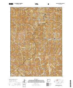
2020 Map of Josephine Mountain
USGS Topo · Published 2020About this map
Kalmiopsis Rim snakes through this high-elevation landscape within the Siskiyou National Forest, marking the boundary between Curry and Josephine counties. This terrain is defined by its dramatic drainage networks, where the Chetco Wild and Scenic River and the Little Chetco River meet at the western edge of the quadrangle. The lack of modern road infrastructure underscores the area's character as a preserved wilderness, with only isolated structures like Bailey Cabin and Emily Cabin indicating human presence in the backcountry. From the heights of Josephine Mtn and Fiddler Mtn, the landscape drops into deep drainages like Fiddler Gulch and Lightning Gulch. The presence of Rough and Ready Lakes and Babyfoot Lake high in the basins suggests the complex glacial and hydrological history that has shaped this corner of Southwest Oregon.
Find a feature on this map
50 named features on this map. Tap any name to fly to it.
Don’t see what you’re looking for? This feature index may not catch every label — zoom into the map to look around manually.
Map Details
Editions of this 2020 Josephine Mountain Map
This is the sole edition of this map. No revisions or reprints were ever made.
Other maps of this area

1917 · Kerby
USGS Topo · 1:125,000

1918 · Kerby
USGS Topo · 1:125,000

1945 · Kerby
USGS Topo · 1:125,000

1954 · Cave Junction
USGS Topo · 1:62,500

1954 · Selma
USGS Topo · 1:62,500

1954 · Chetco Peak
USGS Topo · 1:62,500

1954 · Pearsoll Peak
USGS Topo · 1:62,500

1955 · Medford
USGS Topo · 1:250,000

1957 · Medford
USGS Topo · 1:250,000

1958 · Medford
USGS Topo · 1:250,000