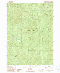
1989 Map of Josephine Mountain
USGS Topo · Published 1989About this map
Josephine Mountain and Fiddler Mountain dominate this corner of the Siskiyou National Forest near the border of Curry and Josephine counties. This terrain is marked by historical resource extraction and remote outposts, including the Alberg Mine and scattered sites like Bailey Cabin (site) and Emily Cabin. The hydrological network is dense, with the Little Chetco River and Rough and Ready Creek carving through the landscape, while high-elevation features like Babyfoot Lake and Cold Spring provide natural landmarks. Traces of human engineering appear in the form of the Chetco Ditch and various 4wd tracks that connect remote points such as Onion Camp and the Radio Towers atop Hungry Hill. The western portion is largely protected within the Kalmiopsis Wilderness, preserving a primitive landscape where names like Hawks Rest and Doe Gap hint at the area's wild character.
Find a feature on this map
43 named features on this map. Tap any name to fly to it.
Don’t see what you’re looking for? This feature index may not catch every label — zoom into the map to look around manually.
Map Details
Editions of this 1989 Josephine Mountain Map
This is the sole edition of this map. No revisions or reprints were ever made.
Other maps of this area

1917 · Kerby
USGS Topo · 1:125,000

1918 · Kerby
USGS Topo · 1:125,000

1945 · Kerby
USGS Topo · 1:125,000

1954 · Cave Junction
USGS Topo · 1:62,500

1954 · Selma
USGS Topo · 1:62,500

1954 · Chetco Peak
USGS Topo · 1:62,500

1954 · Pearsoll Peak
USGS Topo · 1:62,500

1955 · Medford
USGS Topo · 1:250,000

1957 · Medford
USGS Topo · 1:250,000

1958 · Medford
USGS Topo · 1:250,000