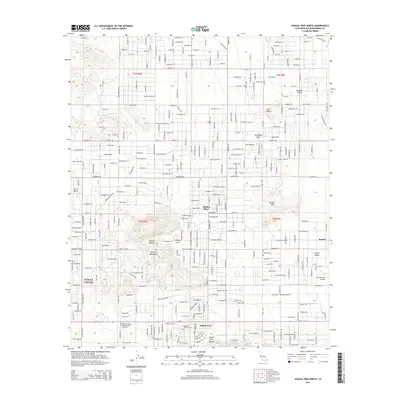
2015 Map of Joshua Tree North
USGS Topo · Published 2015About this map
Yucca Valley and the neighboring community of Joshua Tree anchor this high desert landscape during a period of significant residential expansion. The map details a dense network of suburban streets named for celestial bodies and minerals, such as Mercury Dr and Jadeite St, which transition into the undeveloped terrain of the Partlett Mountains and Bunker Mtn. Local infrastructure is well-defined, including the Roy Williams Airport and the Mountain Valley Memorial Park Cemetery near the southern edge. The topography is shaped by the Mojave Desert environment, with notable features like the Moonlight Mesa and the ephemeral Hidden River winding through the basin. Smaller settlements like Yucca Mesa, Sunfair, and Joshua Cove illustrate the scattered development patterns of San Bernardino County in the mid-2010s, where residential blocks sit in close proximity to the natural drainages of Coyote Hole Canyon.
Find a feature on this map
178 named features on this map. Tap any name to fly to it.
Don’t see what you’re looking for? This feature index may not catch every label — zoom into the map to look around manually.
Map Details
Editions of this 2015 Joshua Tree North Map
This is the sole edition of this map. No revisions or reprints were ever made.
Other maps of this area

1953 · San Bernardino
USGS Topo · 1:250,000

1955 · Goat Mountain
USGS Topo · 1:24,000

1955 · Deadman Lake SW
USGS Topo · 1:24,000

1955 · Twentynine Palms
USGS Topo · 1:62,500

1955 · Emerson Lake
USGS Topo · 1:62,500
1955 · Deadman Lake
USGS Topo · 1:62,500

1955 · Joshua Tree
USGS Topo · 1:62,500

1956 · San Bernardino
USGS Topo · 1:250,000

1957 · San Bernardino
USGS Topo · 1:250,000

1958 · San Bernardino
USGS Topo · 1:250,000