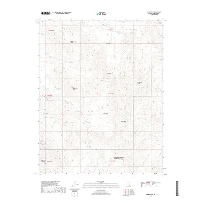
2018 Map of Jumbo Peak
USGS Topo · Published 2018About this map
Jumbo Peak stands as the central landmark of this high-desert landscape in the South Virgin Mountains, where the northern reaches of the Lake Mead National Recreation Area meet the Mojave Desert. The map reveals a complex network of arid drainage systems, most notably Gregg Wash and Scanlon Wash, which define the deep erosion of the terrain. A single artery of human movement, Scanlon Ferry Rd, cuts through the west, hinting at the historical routes used to access the Colorado River valley. High-altitude features such as Anderson Ridge and Rattlesnake Peak overlook secluded basins like Cedar Basin and the aptly named Hells Kitchen. Scattered water sources, including Jumbo Spring and Turkey Spring, represent critical points in this environment, while the vast Garnet Valley spreads across the southwest, illustrating the geologic scale of the eastern Nevada wilderness.
Find a feature on this map
37 named features on this map. Tap any name to fly to it.
Don’t see what you’re looking for? This feature index may not catch every label — zoom into the map to look around manually.
Map Details
Editions of this 2018 Jumbo Peak Map
This is the sole edition of this map. No revisions or reprints were ever made.
Other maps of this area

1886 · Saint Thomas
USGS Topo · 1:250,000

1893 · Saint Thomas
USGS Topo · 1:250,000

1926 · Bonelli
USGS Topo · 1:96,000

1953 · Overton Beach
USGS Topo · 1:62,500

1953 · Iceberg Canyon
USGS Topo · 1:62,500

1953 · Gold Butte
USGS Topo · 1:62,500

1953 · Virgin Basin
USGS Topo · 1:62,500

1954 · Las Vegas
USGS Topo · 1:250,000

1957 · Las Vegas
USGS Topo · 1:250,000

1959 · Las Vegas
USGS Topo · 1:250,000