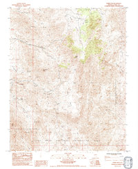
1983 Map of Jumbo Peak
USGS Topo · Published 1984About this map
Jumbo Peak and Bonelli Peak dominate this arid Clark County landscape as it appeared in the early 1980s. The terrain is characterized by a complex network of dry washes and canyons, including the evocative Hells Kitchen and Cottonwood Canyon. A history of mineral exploration is evident throughout the quadrangle, with numerous prospects and established sites such as the Radio Crystal Mine, Nevada Mica Mine, and Windmill Mine scattered among the high ridges.
Find a feature on this map
33 named features on this map. Tap any name to fly to it.
Don’t see what you’re looking for? This feature index may not catch every label — zoom into the map to look around manually.
Map Details
Editions of this 1983 Jumbo Peak Map
This is the sole edition of this map. No revisions or reprints were ever made.
Other maps of this area

1886 · Saint Thomas
USGS Topo · 1:250,000

1893 · Saint Thomas
USGS Topo · 1:250,000

1926 · Bonelli
USGS Topo · 1:96,000

1953 · Overton Beach
USGS Topo · 1:62,500

1953 · Iceberg Canyon
USGS Topo · 1:62,500

1953 · Gold Butte
USGS Topo · 1:62,500

1953 · Virgin Basin
USGS Topo · 1:62,500

1954 · Las Vegas
USGS Topo · 1:250,000

1957 · Las Vegas
USGS Topo · 1:250,000

1959 · Las Vegas
USGS Topo · 1:250,000