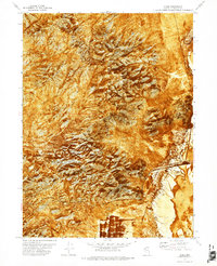
1971 Map of Jungo
USGS Topo · Published 1975About this map
Jungo stands as a lonely outpost in the Humboldt County desert, positioned where the Western Pacific railroad cuts through the arid landscape. This 1970s orthophotomap combines aerial imagery with topographic precision, revealing the stark transition from the high ridges of the Antelope Range down to the expansive Alkali Flats. The settlement's infrastructure is sparse, dominated by the railway and a Water Tank, reflecting its role as a remote siding in the Great Basin.
Find a feature on this map
10 named features on this map. Tap any name to fly to it.
Don’t see what you’re looking for? This feature index may not catch every label — zoom into the map to look around manually.
Map Details
Editions of this 1971 Jungo Map
This is the sole edition of this map. No revisions or reprints were ever made.
Other maps of this area

1886 · Disaster
USGS Topo · 1:250,000

1893 · Disaster
USGS Topo · 1:250,000

1931 · Lovelock
USGS Topo · 1:250,000

1935 · Lovelock
USGS Topo · 1:250,000

1954 · Vya
USGS Topo · 1:250,000

1955 · Lovelock
USGS Topo · 1:250,000

1958 · Vya
USGS Topo · 1:250,000

1959 · Lovelock
USGS Topo · 1:250,000

1962 · Vya
USGS Topo · 1:250,000

1966 · Donna Schee Peak
USGS Topo · 1:62,500