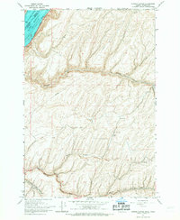
1966 Map of Juniper Canyon
USGS Topo · Published 1967About this map
Lake Wallula dominates the northwest corner of this mid-1960s landscape, formed where the Columbia River flows south toward the border between Washington and Oregon. The Union Pacific railroad hugs the shoreline, providing a vital transportation corridor through this agricultural and arid terrain. The interior is defined by a series of deep drainages, including Juniper Canyon, McCall Canyon, and Cold Springs Canyon, which cut through the high plateau.
Find a feature on this map
21 named features on this map. Tap any name to fly to it.
Don’t see what you’re looking for? This feature index may not catch every label — zoom into the map to look around manually.
Map Details
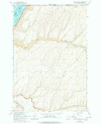
Editions of this 1966 Juniper Canyon Map
2 editions found
Other maps of this area

1908 · Umatilla
USGS Topo · 1:125,000

1915 · Wallulah
USGS Topo · 1:96,000

1917 · Pasco
USGS Topo · 1:125,000

1918 · Wallula
USGS Topo · 1:125,000

1935 · Pendleton
USGS Topo · 1:125,000

1953 · Pendleton
USGS Topo · 1:250,000

1953 · Walla Walla
USGS Topo · 1:250,000

1956 · Pendleton
USGS Topo · 1:250,000

1958 · Walla Walla
USGS Topo · 1:250,000

1962 · Juniper
USGS Topo · 1:24,000