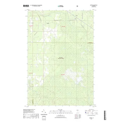
2019 Map of Juniper
USGS Topo · Published 2019About this map
Hiawatha National Forest dominates this section of the Upper Peninsula, where the landscape is defined by an intricate network of wetlands and small watercourses. The drainage patterns of the Little Indian River and the various branches of Stutts Creek, including the North Branch and Middle Branch, illustrate the hydrological complexity of this forest environment. Small settlements and points of interest such as Evelyn, Doty, and Juniper are linked by a system of recreational trails utilizing old transportation corridors. These include the Haywire Grade ATV and the Wetmore-Munising Snomo, reflecting the transition from industrial timber extraction to a landscape primarily managed for conservation and outdoor recreation. The map also captures the Alger and Schoolcraft County line as it cuts through dense marshland near Scotts Marsh and Stump Lake.
Find a feature on this map
25 named features on this map. Tap any name to fly to it.
Don’t see what you’re looking for? This feature index may not catch every label — zoom into the map to look around manually.
Map Details
Editions of this 2019 Juniper Map
This is the sole edition of this map. No revisions or reprints were ever made.
Other maps of this area

1931 · Shingleton SW
USGS Topo · 1:31,680

1931 · Steuben NW
USGS Topo · 1:31,680

1931 · Skeels Lake NE
USGS Topo · 1:31,680

1931 · Munising SE
USGS Topo · 1:31,680

1958 · Corner Lake
USGS Topo · 1:62,500

1958 · Munising
USGS Topo · 1:62,500

1958 · Shingleton
USGS Topo · 1:62,500
1958 · Steuben
USGS Topo · 1:62,500

1958 · Marquette
USGS Topo · 1:250,000

1960 · Marquette
USGS Topo · 1:250,000