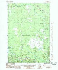
1985 Map of Juniper
USGS Topo · Published 1985About this map
Juniper and the surrounding woodlands of the Hiawatha National Forest define this 1985 landscape on the border of Alger and Schoolcraft counties. The map records the remnants of industrial logging and transit, most notably the Old RR Grade (Coalwood), which has been repurposed as the Coalwood Recreation Trail. Small settlements like Doty and Evelyn are situated near the North Branch Stutts Creek, highlighting the sparse, timber-oriented development of the Upper Peninsula.
Find a feature on this map
24 named features on this map. Tap any name to fly to it.
Don’t see what you’re looking for? This feature index may not catch every label — zoom into the map to look around manually.
Map Details
Editions of this 1985 Juniper Map
This is the sole edition of this map. No revisions or reprints were ever made.
Other maps of this area

1931 · Shingleton SW
USGS Topo · 1:31,680

1931 · Steuben NW
USGS Topo · 1:31,680

1931 · Skeels Lake NE
USGS Topo · 1:31,680

1931 · Munising SE
USGS Topo · 1:31,680

1958 · Corner Lake
USGS Topo · 1:62,500

1958 · Munising
USGS Topo · 1:62,500

1958 · Shingleton
USGS Topo · 1:62,500
1958 · Steuben
USGS Topo · 1:62,500

1958 · Marquette
USGS Topo · 1:250,000

1960 · Marquette
USGS Topo · 1:250,000