
1962 Map of Juniper
USGS Topo · Published 1963About this map
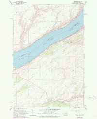
Lake Wallula dominates this reach of the Columbia River along the border of Oregon and Washington, following the completion of the McNary Dam. The landscape reflects a transition in river-based commerce and transportation during the early 1960s, where the rising water level created a vast reservoir over the previous river channel. Along the southern banks in Umatilla County, the Union Pacific railroad parallels the shoreline near the settlement of Juniper, while the Spokane Portland and Seattle railroad tracks follow the northern bank in Benton County. Inland from the water, the terrain is cut by deep draws including Spukshowki Canyon and Cold Springs Canyon, the latter featuring prominent storage bins that hint at the agricultural activity of the surrounding plateau. This survey also records infrastructure like a pipeline and a Gaging Sta, essential for managing the harnessed river.
Find a feature on this map
16 named features on this map. Tap any name to fly to it.
Don’t see what you’re looking for? This feature index may not catch every label — zoom into the map to look around manually.
Map Details
Editions of this 1962 Juniper Map
2 editions found
Other maps of this area

1908 · Umatilla
USGS Topo · 1:125,000

1915 · Wallulah
USGS Topo · 1:96,000

1917 · Pasco
USGS Topo · 1:125,000

1918 · Wallula
USGS Topo · 1:125,000

1935 · Pendleton
USGS Topo · 1:125,000

1953 · Pendleton
USGS Topo · 1:250,000

1953 · Walla Walla
USGS Topo · 1:250,000

1956 · Pendleton
USGS Topo · 1:250,000

1958 · Walla Walla
USGS Topo · 1:250,000

1962 · Hat Rock
USGS Topo · 1:24,000