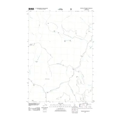
2011 Map of Jureano Mountain
USGS Topo · Published 2011About this map
Jureano Mountain towers over a landscape defined by its deep mining history in Lemhi County. The intricate network of drainage systems, including Napias Creek and Arnett Creek, provides the backdrop for numerous extraction sites such as the Haidee Mine, Italian Mine, and the Ringbone Cayuse Mine. Near the junction of Panther Creek and Cliff Creek, the Leacock Ranch stands as a point of interest for those tracing family history in this remote section of the Salmon River mountains. The geography is punctuated by significant landmarks like the Jureano Placer Diggings and California Bar, while the Napias Creek Falls and a Waterfall mark the steep descent of the local waterways.
Find a feature on this map
38 named features on this map. Tap any name to fly to it.
Don’t see what you’re looking for? This feature index may not catch every label — zoom into the map to look around manually.
Map Details
Editions of this 2011 Jureano Mountain Map
This is the sole edition of this map. No revisions or reprints were ever made.
Other maps of this area

1950 · Blackbird Mtn
USGS Topo · 1:62,500

1950 · Leesburg
USGS Topo · 1:62,500

1951 · Leesburg
USGS Topo · 1:62,500

1951 · Blackbird Mtn
USGS Topo · 1:62,500

1956 · Elk City
USGS Topo · 1:250,000

1960 · Elk City
USGS Topo · 1:250,000

1960 · Ulysses Mtn
USGS Topo · 1:62,500

1960 · Shoup
USGS Topo · 1:62,500

1982 · Bighorn Crags
USGS Topo · 1:100,000
1989 · Leesburg
USGS Topo · 1:24,000