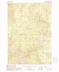
1989 Map of Jureano Mountain
USGS Topo · Published 1989About this map
Haidee Mine and the Italian Mine sit at the head of a complex drainage network within the Salmon National Forest. This 1980s provisional survey shows the industrial footprint of high-country mining, with Tailings clearly marked near the gulches. The terrain is defined by the massive bulk of Jureano Mountain, which rises toward the Jureano Lookout, and the prominent Phelan Ridge to the east.
Find a feature on this map
34 named features on this map. Tap any name to fly to it.
Don’t see what you’re looking for? This feature index may not catch every label — zoom into the map to look around manually.
Map Details
Editions of this 1989 Jureano Mountain Map
This is the sole edition of this map. No revisions or reprints were ever made.
Other maps of this area

1950 · Blackbird Mtn
USGS Topo · 1:62,500

1950 · Leesburg
USGS Topo · 1:62,500

1951 · Leesburg
USGS Topo · 1:62,500

1951 · Blackbird Mtn
USGS Topo · 1:62,500

1956 · Elk City
USGS Topo · 1:250,000

1960 · Elk City
USGS Topo · 1:250,000

1960 · Ulysses Mtn
USGS Topo · 1:62,500

1960 · Shoup
USGS Topo · 1:62,500

1982 · Bighorn Crags
USGS Topo · 1:100,000
1989 · Leesburg
USGS Topo · 1:24,000