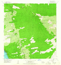
1959 Map of Kailua
USGS Topo · Published 1966About this map
The coastal settlement of Kailua sits at the edge of the Pacific, serving as the primary hub for the North Kona District during the mid-century. This terrain is defined by the massive descent from the mountain slopes to the sea, where ancient and recent geological activity is visible through the Kaupulehu Lava Flow and features like Kaupulehu Crater. The upland areas are dominated by significant forest reserves, including the Honuaula Forest Reserve and Waiaha Springs Forest Reserve, which provide a stark contrast to the homestead lands below.
Find a feature on this map
61 named features on this map. Tap any name to fly to it.
Don’t see what you’re looking for? This feature index may not catch every label — zoom into the map to look around manually.
Map Details
Editions of this 1959 Kailua Map
3 editions found

Other maps of this area

1928 · Puako
USGS Topo · 1:62,500

1928 · Kailua
USGS Topo · 1:62,500

1954 · Hawaii North
USGS Topo · 1:250,000

1959 · Hawaii North
USGS Topo · 1:250,000

1959 · Kiholo
USGS Topo · 1:24,000

1959 · Hualalai
USGS Topo · 1:24,000

1959 · Puu Lehua
USGS Topo · 1:24,000

1959 · Makalawena
USGS Topo · 1:24,000

1959 · Keahole Point
USGS Topo · 1:24,000
1959 · Puu Anahulu
USGS Topo · 1:24,000