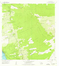
1959 Map of Kailua
USGS Topo · Published 1975About this map
Kailua serves as the coastal hub in this mid-century survey of the North Kona District, where the town's position on Kailua Bay meets the developing infrastructure of the Kuakini Highway. Moving inland, the landscape rises toward the volcanic heights of Hualalai, characterized by a complex system of homesteads and land divisions such as the Kealakehe Homesteads and Kalaoa-Ooma Homesteads. These narrow land strips reflect traditional land management patterns reaching from the shoreline into the upland forests.
Find a feature on this map
80 named features on this map. Tap any name to fly to it.
Don’t see what you’re looking for? This feature index may not catch every label — zoom into the map to look around manually.
Map Details
Editions of this 1959 Kailua Map
3 editions found

Other maps of this area

1928 · Puako
USGS Topo · 1:62,500

1928 · Kailua
USGS Topo · 1:62,500

1954 · Hawaii North
USGS Topo · 1:250,000

1959 · Hawaii North
USGS Topo · 1:250,000

1959 · Kiholo
USGS Topo · 1:24,000

1959 · Hualalai
USGS Topo · 1:24,000

1959 · Puu Lehua
USGS Topo · 1:24,000

1959 · Makalawena
USGS Topo · 1:24,000

1959 · Keahole Point
USGS Topo · 1:24,000
1959 · Puu Anahulu
USGS Topo · 1:24,000