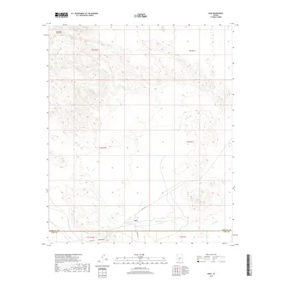
2018 Map of Kaka
USGS Topo · Published 2018About this map
The settlement of Kaka serves as the focal point of this arid landscape, situated at the intersection of Indian Rte 242 and Indian Rte 23. The geography is defined by broad alluvial drainage systems, notably the Kohatk Wash and Kaka Wash, which carve through the desert terrain south of the Sano Tank Mountains. These ephemeral waterways shape the Kaka Valley, illustrating the classic basin-and-range hydrology where seasonal runoff dictates the placement of infrastructure and habitation. The presence of Pipeline Rd running through the southern reaches of the quadrangle highlights the intersection of modern utility corridors with traditional routes. Straddling the Maricopa Co Pima Co boundary, the area maintains a sparse but deliberate network of roads that reflect the remote character of this region in the late 2010s.
Find a feature on this map
15 named features on this map. Tap any name to fly to it.
Don’t see what you’re looking for? This feature index may not catch every label — zoom into the map to look around manually.
Map Details
Editions of this 2018 Kaka Map
This is the sole edition of this map. No revisions or reprints were ever made.
Other maps of this area

1941 · Vekol Mountains
USGS Topo · 1:62,500

1942 · Vekol Mountains
USGS Topo · 1:62,500

1953 · Ajo
USGS Topo · 1:250,000

1957 · Ajo
USGS Topo · 1:250,000

1958 · Ajo
USGS Topo · 1:250,000

1958 · Kaka
USGS Topo · 1:62,500

1962 · Ajo
USGS Topo · 1:250,000

1963 · Ajo
USGS Topo · 1:250,000

1963 · Gu Achi
USGS Topo · 1:62,500

1963 · Cimarron Peak
USGS Topo · 1:62,500