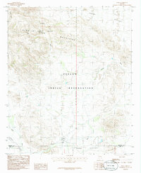
1986 Map of Kaka
USGS Topo · Published 1986About this map
The settlement of Kaka sits at the base of the Sand Air Force Range Mountains, serving as a focal point within the Papago Indian Reservation during the mid-1980s. This desert landscape is defined by the drainage patterns of Kohatk Wash and Kaka Wash, which carve through the Vekol Valley and Kaka Valley. The map reveals a land structured by traditional indigenous residency and military airspace, with the Gila and Salt River Meridian serving as a primary surveying baseline. Local life is centered around the small cluster of buildings at Kaka, including a Cem and several water tanks that suggest the vital importance of moisture management in this arid environment. Elevation markers like BM 2256 provide precise topographical data for researchers studying the transition from the valley floor to the prominent peaks of the Luke range.
Find a feature on this map
16 named features on this map. Tap any name to fly to it.
Don’t see what you’re looking for? This feature index may not catch every label — zoom into the map to look around manually.
Map Details
Editions of this 1986 Kaka Map
This is the sole edition of this map. No revisions or reprints were ever made.
Other maps of this area

1941 · Vekol Mountains
USGS Topo · 1:62,500

1942 · Vekol Mountains
USGS Topo · 1:62,500

1953 · Ajo
USGS Topo · 1:250,000

1957 · Ajo
USGS Topo · 1:250,000

1958 · Ajo
USGS Topo · 1:250,000

1958 · Kaka
USGS Topo · 1:62,500

1962 · Ajo
USGS Topo · 1:250,000

1963 · Ajo
USGS Topo · 1:250,000

1963 · Gu Achi
USGS Topo · 1:62,500

1963 · Cimarron Peak
USGS Topo · 1:62,500