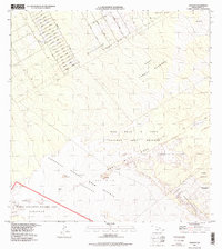
1995 Map of Kalalua
USGS Topo · Published 1998About this map
Volcanic activity and the gradual encroachment of residential development define this 1995 planimetry of the East Rift Zone on the island of Hawaii. The map documents the extensive reach of the Lava Flow of 1977 and the Lava Flow of 1969, illustrating how these geothermal events reshaped the terrain within Hawaii Volcanoes National Park and neighboring conservation lands. In the northwest corner, a dense residential grid in Keaau features named streets like Ahi Avenue and Punawai Avenue, contrasting sharply with the raw volcanic landscape to the southeast.
Find a feature on this map
53 named features on this map. Tap any name to fly to it.
Don’t see what you’re looking for? This feature index may not catch every label — zoom into the map to look around manually.
Map Details
Editions of this 1995 Kalalua Map
2 editions found
Other maps of this area

1917 · Hilo
USGS Topo · 1:62,500

1922 · Puna
USGS Topo · 1:62,500

1924 · Makuu
USGS Topo · 1:62,500

1924 · Puna
USGS Topo · 1:62,500

1924 · Kalapana
USGS Topo · 1:62,500

1932 · Hilo
USGS Topo · 1:62,500

1954 · Hawaii South
USGS Topo · 1:250,000

1954 · Hawaii North
USGS Topo · 1:250,000

1959 · Hawaii South
USGS Topo · 1:250,000

1959 · Hawaii North
USGS Topo · 1:250,000