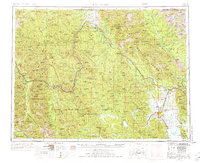
1957 Map of Kalispell
USGS Topo · Published 1976About this map
The Kootenai River and the high peaks of the Purcell Mountains anchor this 1957 survey of northwest Montana. This edition captures the regional landscape during a period of transition, showing the newly created Lake Koocanusa behind the Libby Dam. The map highlights the critical transportation corridors that shaped the Flathead Valley, including the Great Northern railroad line connecting Whitefish, Columbia Falls, and Kalispell.
Find a feature on this map
250 named features on this map. Tap any name to fly to it.
Don’t see what you’re looking for? This feature index may not catch every label — zoom into the map to look around manually.
Map Details
Editions of this 1957 Kalispell Map
3 editions found

Other maps of this area

1904 · Chief Mountain
USGS Topo · 1:125,000

1906 · Kintla Lakes
USGS Topo · 1:125,000

1909 · Cataldo
USGS Topo · 1:125,000

1911 · Cataldo
USGS Topo · 1:125,000

1911 · Priest Lake
USGS Topo · 1:250,000

1913 · Priest Lake
USGS Topo · 1:250,000

1913 · Stryker
USGS Topo · 1:125,000

1914 · Nyack
USGS Topo · 1:125,000

1916 · Stryker
USGS Topo · 1:125,000

1920 · Flathead Lake
USGS Topo · 1:125,000