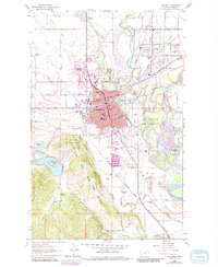
1962 Map of Kalispell
USGS Topo · Published 1983About this map
The Stillwater River and Whitefish River converge just east of Kalispell in this detailed survey of Flathead County. The map documents a significant era of institutional growth, shown through the concentration of facilities like the Flathead Co High Sch, Central Jr High Sch, and General Hospital. Local industry and infrastructure are represented by several Gravel Pit operations and the Burlington Northern railroad lines that serve the city's eastern edge.
Find a feature on this map
64 named features on this map. Tap any name to fly to it.
Don’t see what you’re looking for? This feature index may not catch every label — zoom into the map to look around manually.
Map Details
Editions of this 1962 Kalispell Map
3 editions found
Other maps of this area

1943 · Kalispell
USGS Topo · 1:125,000

1957 · Kalispell
USGS Topo · 1:250,000

1960 · Kalispell
USGS Topo · 1:250,000

1961 · Kalispell
USGS Topo · 1:250,000

1962 · Kila
USGS Topo · 1:24,000

1962 · Columbia Falls South
USGS Topo · 1:24,000

1962 · Rose Crossing
USGS Topo · 1:24,000

1962 · Blue Grass Ridge
USGS Topo · 1:24,000

1962 · Lion Mountain
USGS Topo · 1:24,000

1962 · Somers
USGS Topo · 1:24,000