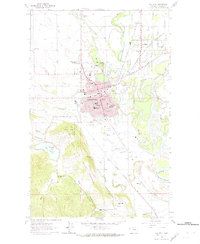
1962 Map of Kalispell
USGS Topo · Published 1974About this map
Kalispell serves as the focal point of this Flathead Valley landscape, where the Stillwater River and Whitefish River converge before meeting the Flathead River. The 1962 fieldwork reveals a community deeply rooted in its geography, with civic landmarks like the Courthouse and City Hall anchoring the downtown grid. To the west, the topography rises sharply into the Lone Pine State Park, overlooking the valley floor and Foy Lake. The presence of the Great Northern railroad and several gravel pits indicates the industrial underpinnings of the era, while the eastern edge of town shows the growing residential footprint of Evergreen. Numerous rural institutions are documented, including the Demersville Cem and a variety of local schools such as Elrod Sch and Peterson Sch, providing essential data points for local historians and genealogists studying the mid-century development of Flathead County.
Find a feature on this map
63 named features on this map. Tap any name to fly to it.
Don’t see what you’re looking for? This feature index may not catch every label — zoom into the map to look around manually.
Map Details
Editions of this 1962 Kalispell Map
3 editions found
Other maps of this area

1943 · Kalispell
USGS Topo · 1:125,000

1957 · Kalispell
USGS Topo · 1:250,000

1960 · Kalispell
USGS Topo · 1:250,000

1961 · Kalispell
USGS Topo · 1:250,000

1962 · Kila
USGS Topo · 1:24,000

1962 · Columbia Falls South
USGS Topo · 1:24,000

1962 · Rose Crossing
USGS Topo · 1:24,000

1962 · Blue Grass Ridge
USGS Topo · 1:24,000

1962 · Lion Mountain
USGS Topo · 1:24,000

1962 · Somers
USGS Topo · 1:24,000