
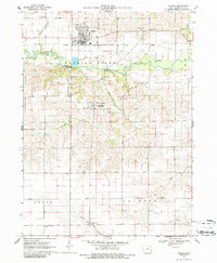
1969 Map of Kalona
USGS Topo · Published 1971About this map
The Chicago Rock Island and Pacific railroad tracks bisect the northern half of this rural Iowa landscape, connecting the hub of Kalona with the surrounding agricultural townships. The meandering English River dominates the central topography, flanked by oxbows and marshy features like Lily Pond. This 1960s survey provides a clear view of the settlement at Richmond and the distribution of localized infrastructure that supported small-town life. Rural education and community heritage are anchored by scattered sites such as Snake Hollow Sch, Middleburg Sch, and Prairie Flower Sch. Genealogists will find a wealth of early burial grounds, including the Sharon Hill Cem, Holy Trinity Cem, and Snider Cem, which offer a window into the family names that established these communities within Cedar and Jackson townships.
Find a feature on this map
22 named features on this map. Tap any name to fly to it.
Don’t see what you’re looking for? This feature index may not catch every label — zoom into the map to look around manually.
Map Details
Editions of this 1969 Kalona Map
2 editions found
Other maps of this area

1891 · Oxford
USGS Topo · 1:62,500

1891 · Iowa City
USGS Topo · 1:62,500

1894 · Oxford
USGS Topo · 1:62,500

1903 · Fairfax
USGS Topo · 1:125,000

1938 · Iowa City
USGS Topo · 1:62,500

1958 · Davenport
USGS Topo · 1:250,000

1961 · Davenport
USGS Topo · 1:250,000

1962 · Davenport
USGS Topo · 1:250,000

1965 · Williamstown
USGS Topo · 1:24,000
1965 · Hills
USGS Topo · 1:24,000