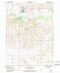
1969 Map of Kalona
USGS Topo · Published 1986About this map
Kalona serves as a primary hub of settlement in this northern Washington County landscape, which is marked by the winding course of the English River. In the late 1960s, the Chicago Rock Island and Pacific railroad bisected the town, connecting it to the broader agricultural economy. South of the river, the village of Richmond sits near Camp Creek, surrounded by a high density of rural institutions. The map reveals a deeply rooted community structure through numerous small landmarks, including the Holy Trinity Cem and several dispersed schools such as Snake Hollow Sch and Middleburg Sch. The terrain transitions from the river valley to the southern townships of Cedar and Jackson, where the headwaters of Goose Creek and Davis Creek begin to drain the countryside.
Find a feature on this map
26 named features on this map. Tap any name to fly to it.
Don’t see what you’re looking for? This feature index may not catch every label — zoom into the map to look around manually.
Map Details
Editions of this 1969 Kalona Map
2 editions found

Other maps of this area

1891 · Oxford
USGS Topo · 1:62,500

1891 · Iowa City
USGS Topo · 1:62,500

1894 · Oxford
USGS Topo · 1:62,500

1903 · Fairfax
USGS Topo · 1:125,000

1938 · Iowa City
USGS Topo · 1:62,500

1958 · Davenport
USGS Topo · 1:250,000

1961 · Davenport
USGS Topo · 1:250,000

1962 · Davenport
USGS Topo · 1:250,000

1965 · Williamstown
USGS Topo · 1:24,000
1965 · Hills
USGS Topo · 1:24,000