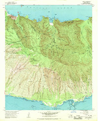
1968 Map of Kamalo
USGS Topo · Published 1970About this map
Ancient Hawaiian engineering and coastal settlement define this 1968 revision of the Molokai shoreline. Along the southern coast, a dense concentration of traditional stone-walled enclosures such as Kakaiaha Fishpond and Panahaha Fishpond demonstrates the sophisticated maritime aquaculture central to the island's history. The map records the cultural landscape near Kamalo and Ualapue, where residents lived between the heights of the Molokai Forest Reserve and the sea. Inland, the sacred Malae Heiau and Hokukano Heiau stand near the Kilohana Sch, marking the continuity of community space. The rugged north shore, defined by massive cliffs and the Pelekunu Bay, shows the transition of human activity through the noted settlement locations at Pelekunu (Site) and Wailau (Site), set against a dramatic terrain of falls like Moeloa Falls.
Find a feature on this map
82 named features on this map. Tap any name to fly to it.
Don’t see what you’re looking for? This feature index may not catch every label — zoom into the map to look around manually.
Map Details
Editions of this 1968 Kamalo Map
This is the sole edition of this map. No revisions or reprints were ever made.
Other maps of this area

1952 · Halawa
USGS Topo · 1:24,000

1952 · Kamalo
USGS Topo · 1:24,000

1952 · Kaunakakai
USGS Topo · 1:24,000

1954 · Maui
USGS Topo · 1:250,000

1966 · Maui
USGS Topo · 1:250,000

1967 · Kaunakakai
USGS Topo · 1:24,000

1968 · Halawa
USGS Topo · 1:24,000

1974 · Maui
USGS Topo · 1:250,000
1983 · Molokai East
USGS Topo · 1:25,000
1993 · Kaunakakai
USGS Topo · 1:24,000