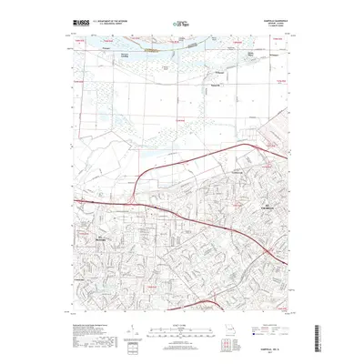
2017 Map of Kampville
USGS Topo · Published 2017About this map
St. Charles and St. Peters dominate the lower half of this landscape, showing the dense residential growth and suburban infrastructure of St. Charles County in the late 2010s. The map traces the historical core and modern expansion around Lindenwood Univ, while older rural vestiges remain visible at Cottleville and Gardnerville. To the north, the terrain transitions sharply into the bottomlands of the Mississippi River, where riverfront settlements like Kampville and McCann Landing sit near large river features including Apple Island and Dardenne Island. Local history is anchored by sites such as Oak Grove Cem and Methodist Cem, while the northern hills reveal geographic markers like Coalbank Hollow. This survey captures a highly developed corridor of Missouri where major thoroughfares like Veterans Memorial Pkwy and Boones Lick Rd serve as primary arteries for the region's commerce.
Find a feature on this map
60 named features on this map. Tap any name to fly to it.
Don’t see what you’re looking for? This feature index may not catch every label — zoom into the map to look around manually.
Map Details
Editions of this 2017 Kampville Map
This is the sole edition of this map. No revisions or reprints were ever made.
Other maps of this area

1903 · O'Fallon
USGS Topo · 1:125,000

1924 · Robertson
USGS Topo · 1:24,000

1927 · St. Charles
USGS Topo · 1:62,500

1931 · Brussels
USGS Topo · 1:62,500

1932 · Manchester NE
USGS Topo · 1:24,000

1933 · Creve Coeur
USGS Topo · 1:24,000

1933 · Saint Charles
USGS Topo · 1:62,500

1937 · Weldon Spring
USGS Topo · 1:24,000

1939 · Brussels
USGS Topo · 1:62,500

1940 · Weldon Spring
USGS Topo · 1:24,000