
1932 Map of Manchester NE
USGS Topo · Published 1932About this map
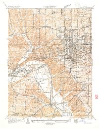
The Missouri River forms the central artery of this 1932 landscape, separating St Charles Co from St Louis Co. Along the southern riverbank, the St Louis City Water Works and St Louis County Water Works are prominent industrial landmarks at Howard Bend. This survey captures the transition from the river-bottom agriculture of Greens Bottom and Bon Homme Island to the rising hills of the Meramec township. Cultural markers of the era include the Rock Island Line railroad and a network of rural schools such as Zion Sch, Union Sch, and Fairmount Sch. The settlements of Chesterfield and Bellefontaine appear as primary community hubs, while Gumbo remains a smaller outpost along the Olive Street Road. From the confluence of Caulks Creek and Bon Homme Creek to the Trinity Ch near the eastern margin, the map provides an intricate look at the local geography before mid-century expansion.
Find a feature on this map
34 named features on this map. Tap any name to fly to it.
Don’t see what you’re looking for? This feature index may not catch every label — zoom into the map to look around manually.
Map Details
Editions of this 1932 Manchester NE Map
This is the sole edition of this map. No revisions or reprints were ever made.
Other maps of this area

1903 · O'Fallon
USGS Topo · 1:125,000

1924 · Robertson
USGS Topo · 1:24,000

1927 · St. Charles
USGS Topo · 1:62,500

1931 · Manchester SE
USGS Topo · 1:24,000

1931 · Brussels
USGS Topo · 1:62,500

1933 · Creve Coeur
USGS Topo · 1:24,000

1933 · Saint Charles
USGS Topo · 1:62,500
1933 · Kirkwood
USGS Topo · 1:24,000

1937 · Weldon Spring
USGS Topo · 1:24,000

1939 · Brussels
USGS Topo · 1:62,500