
1939 Map of Brussels
USGS Topo · Published 1955About this map
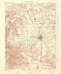
The Mississippi River and Illinois River converge in this pre-war survey, defining a landscape of low-lying islands and river-driven commerce. The map documents the intricate network of river landings such as Poppleton Ldg, Beech Ldg, and Fruitland Ldg that served the agricultural bottoms of Calhoun Co and St Charles Co. These landings, paired with the West Point Ferry and Golden Eagle Ferry, highlight a period when river transit was essential for the isolated peninsular communities.
Find a feature on this map
113 named features on this map. Tap any name to fly to it.
Don’t see what you’re looking for? This feature index may not catch every label — zoom into the map to look around manually.
Map Details
Editions of this 1939 Brussels Map
This is the sole edition of this map. No revisions or reprints were ever made.
Other maps of this area

1903 · O'Fallon
USGS Topo · 1:125,000

1924 · Robertson
USGS Topo · 1:24,000

1927 · St. Charles
USGS Topo · 1:62,500

1930 · Hardin
USGS Topo · 1:62,500

1930 · Jerseyville
USGS Topo · 1:62,500

1931 · Brussels
USGS Topo · 1:62,500

1932 · Manchester NE
USGS Topo · 1:24,000

1933 · Creve Coeur
USGS Topo · 1:24,000
1933 · Jerseyville
USGS Topo · 1:62,500

1933 · Saint Charles
USGS Topo · 1:62,500